


Ihr Einkaufswagen

Kommentar

Alle Bestellungen werden in verarbeitet USD. Während der Inhalt Ihres Warenkorbs derzeit in angezeigt wird CYN, Sie werden mit zur Kasse gehen USD zum aktuellsten Wechselkurs.

Ausverkauft

Einige Artikel sind nicht mehr verfügbar. Ihr Warenkorb wurde aktualisiert.

Haben Sie einen Rabattcode?
Der angewendete Gutscheincode wird in Ihrem Konto gespeichert
Zwischensumme
Rabatt

Dieser Rabattcode kann nicht in Verbindung mit anderen Werbe- oder Rabattangeboten verwendet werden.

Gesamt
Steuern und Versandkosten werden an der Kasse berechnet
Spedizione gratuita su tutti gli ordini!
EUR

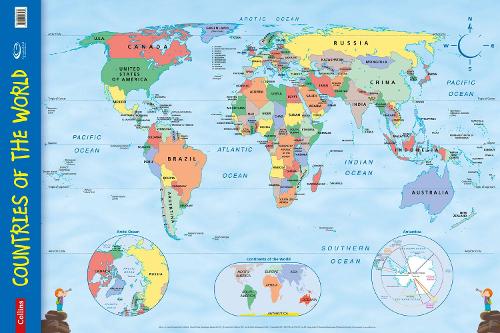
Countries of the World: Wall Map - Collins Primary Atlases (Sheet map, rolled) 1855460

Sale price EUR €4.77 Regular price EUR €9.54

Bestellübersicht

Countries of the World: Wall Map - Collins Primary Atlases (Sheet map, rolled)
4.77
Haben Sie einen Rabattcode?
Der angewendete Gutscheincode wird in Ihrem Konto gespeichert

Zwischensumme
Versandkosten werden an der Kasse berechnet.

ODER

Kaufen Sie mit
Einzelheiten

Every primary school needs this brightly coloured map of the world's countries. Uncluttered with unnecessary detail,this is a great visual aid for kids to learn geography and advance their understanding of the world. The map is clearly labelled with country names and oceans making it ideal for teaching the location of places.

Alongside the large political map there are inset maps of the polar regions and the continents.

This wall chart is laminated on one side and supplied rolled and shrink-wrapped. It is ideal for mounting on a classroom wall or for home study.Dimensions 610 X 915 mm.

Makes learning fun.

Published in association with the Geographical Association.

Publisher: HarperCollins PublishersISBN: 9780007536139Number of pages: 1Weight: 90 gDimensions: 610 x 915 x 26 mm

    Einloggen
    Wenn Sie kein Konto haben, klicken Sie auf Konto erstellenKonto anlegen